2026 Outdoor Photo Story Competition Shortlisted Entries
Somers In Winter
Author: Jess Charlesworth
I had been painting a picture of conquering Mount Somers for the entirety of last summer. Driving tour buses for a living, I constantly pass this alluring mountain while on the way into Kā Tiritiri o te Moana, but I never have time to stop. This one week in late August, there was an abundance of snow in the forecast and a complete lack of work in the tourism field. This left me twiddling my thumbs inside the same four walls, limited in what adventures were on offer.
After shaking off the mid-winter blues, I found a compromise for my summit fever that had been growing throughout the summer. I discovered you could have the perfect overnighter only a stone’s throw from Ōtautahi, all while staying off the tops. A gap in the weather emerged; the clouds parted, and out came two days of seven where the sunshine looked like it might just make an appearance.
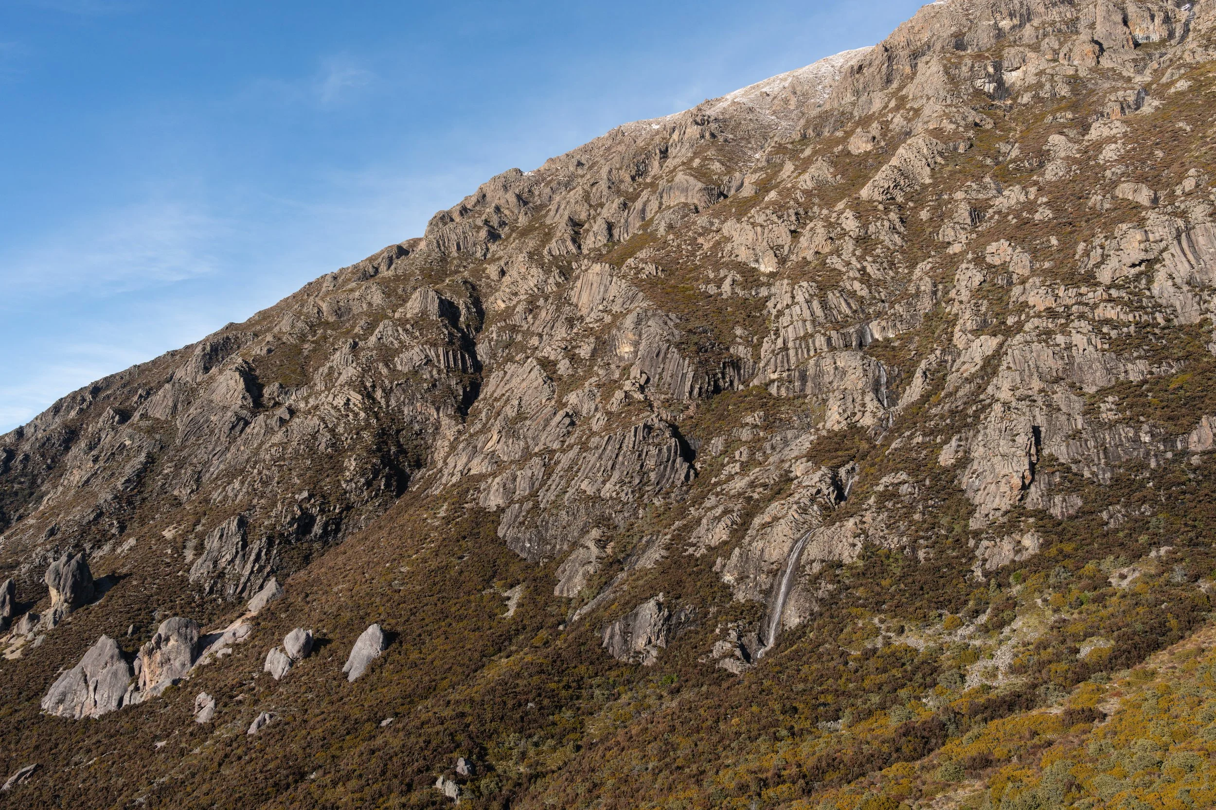
One of my favourite aspects of winter walking is the tranquillity. I found this peace instantly when I arrived at Sharplin Falls Car Park at eight in the morning and realised I was one of only two people there. It was a quiet start, with a couple of birds chattering and the morning frost slowly melting. By starting on the South Face Track, I was able to embrace the finite hours of sun before the rays crept behind the mountains, casting their shadow. Some sections of the track hadn’t seen daylight in weeks, and snow remained at surprisingly low levels.
I meandered over the hills, stopping frequently along the way to capture the changing landscape. On the left, the Canterbury Plains — a patchwork quilt of farmers’ fields. On the right, toppling mountains with a white sheet stretched across the summits. As dusk rolled in, I reached Woolshed Creek Hut. Despite my love of solitude, I was somewhat relieved to be greeted by three other trampers. To be totally honest, being alone in the backcountry in an eerie, empty hut doesn’t always lead to the best night’s sleep.
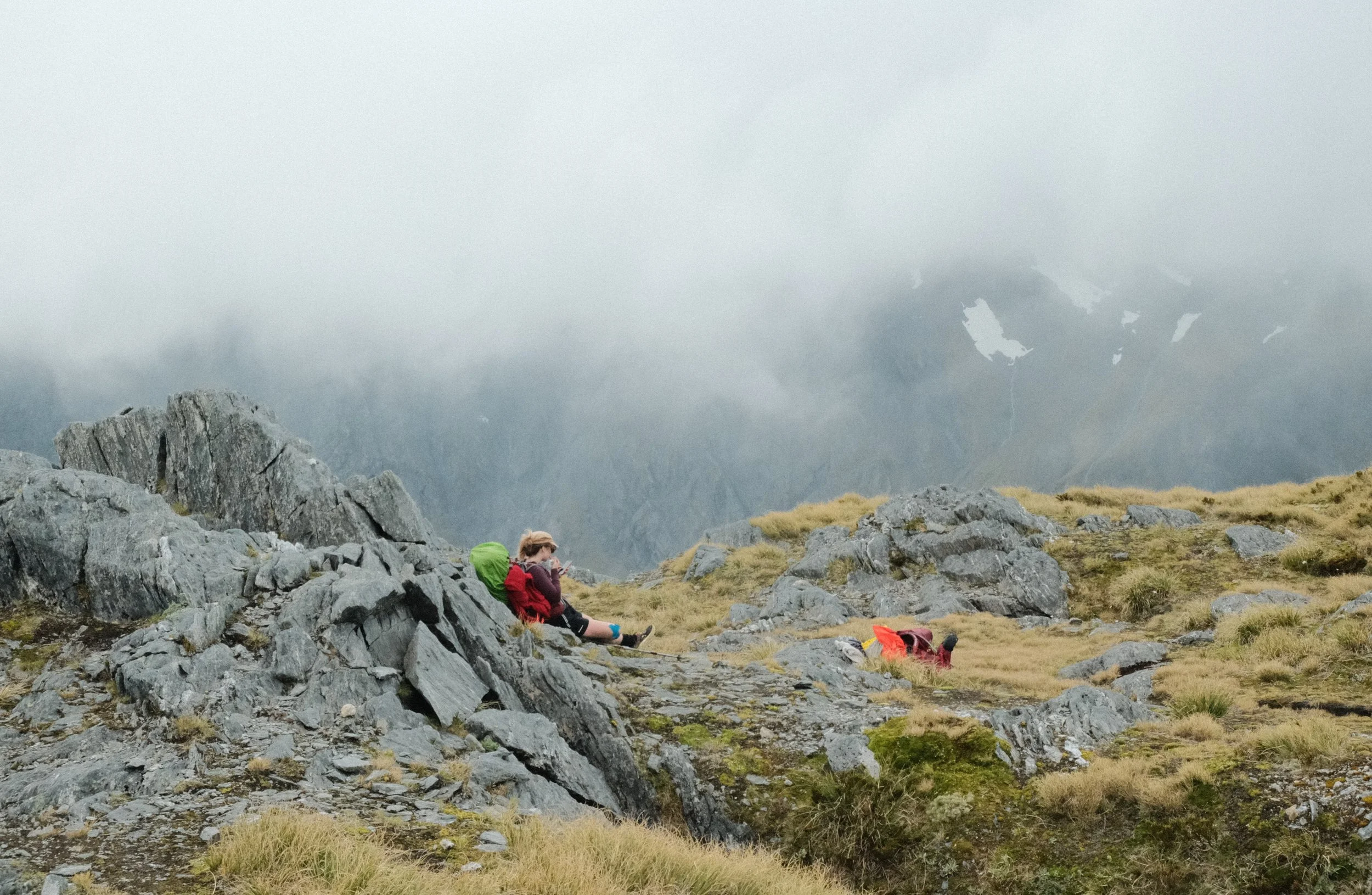
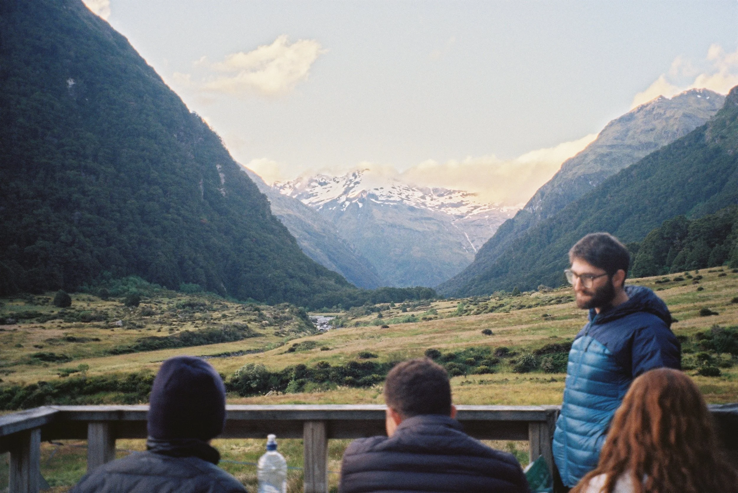
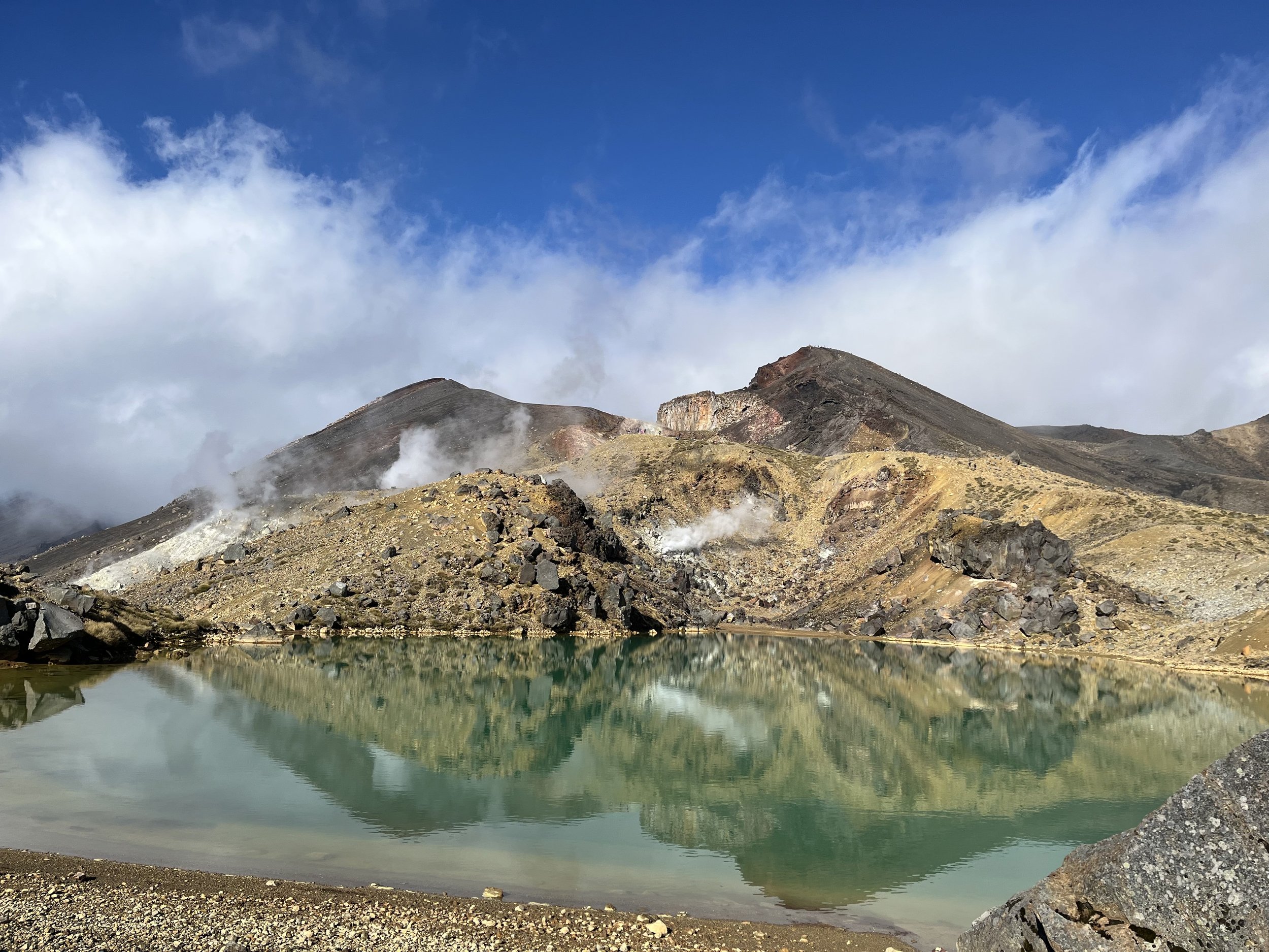
I woke up before sunrise, ready for the “official” Mount Somers Track to the north of the mountain. Only this time, I’d made a friend in the hut called Rayson, who was headed in the same direction. Both of us were keen to get a head start on the ascent to Pinnacles Hut, as the weather in the afternoon was forecast to deteriorate. A hazed pink spread across the valley and slowly burned into a yellow light, revealing the massive rock formations above us. Before we knew it, we were walking at over one thousand metres above sea level, and needle ice crushed beneath our feet. The Pinnacles surrounded us — large, curving, volcanic sculptures that clambered up the side of the mountain.
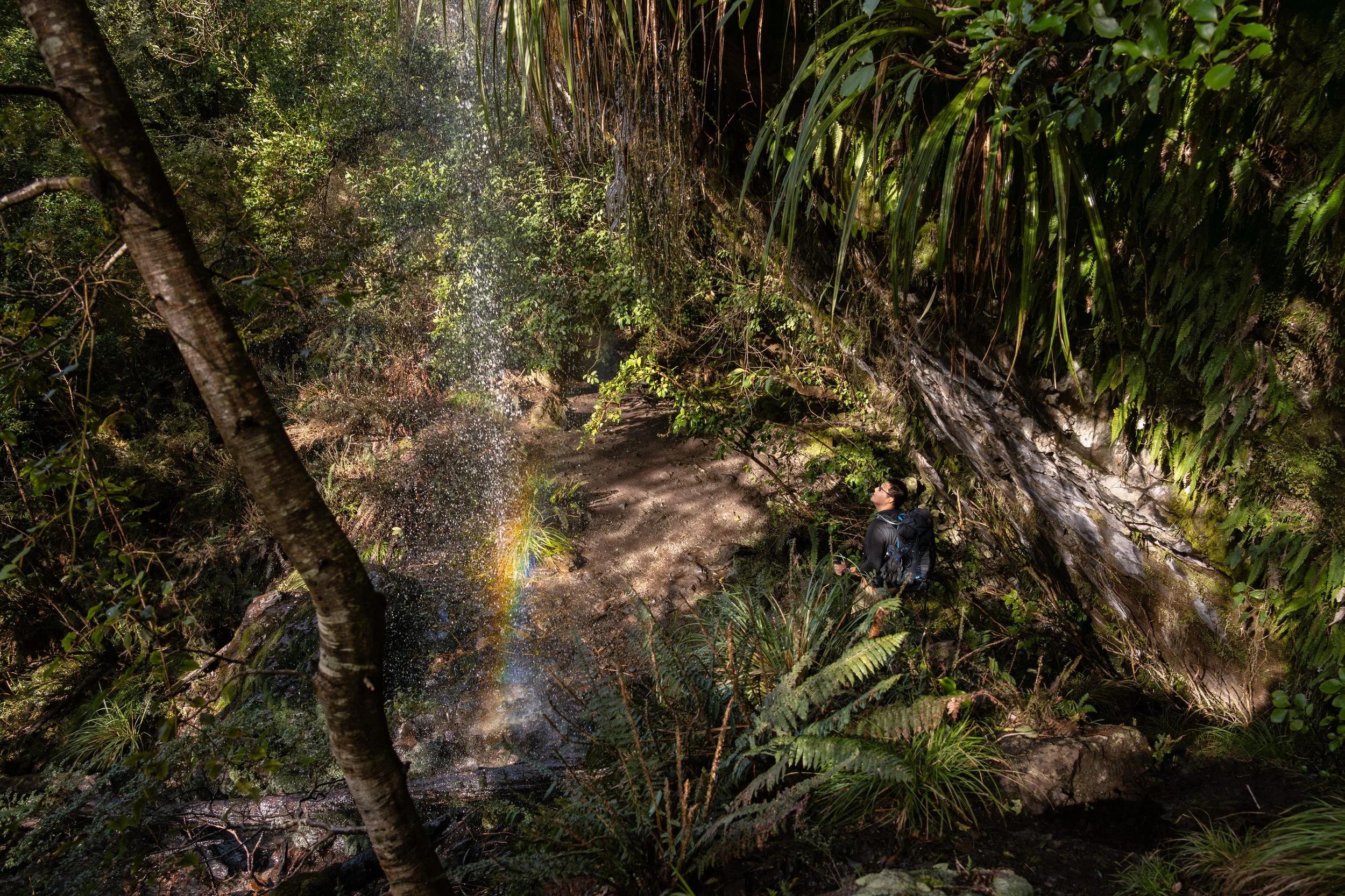
Eventually, we started zigzagging downwards, returning into the depths of the bush. I led myself into the false belief that the tramp was coming to an end. I was delighted to discover I couldn’t have been more wrong. We stumbled upon a series of temporary waterfalls, with the light reflecting through the bush perfectly. There was one instance where Rayson walked behind a cascading waterfall, and the light began to weave through the droplets, erupting into a rainbow. Lasting less than a minute, I managed to hoist my camera out and capture the moment.
Finally, we followed the gently curving Bowyers Stream, cautiously stepping across the boulders beside the river and crossing patches of ice. We had one last push up to the top of Duke’s Knob before winding down, completing the circuit back to Sharplin Falls Car Park.
Gillespie Pass
Author: Abby Faulls
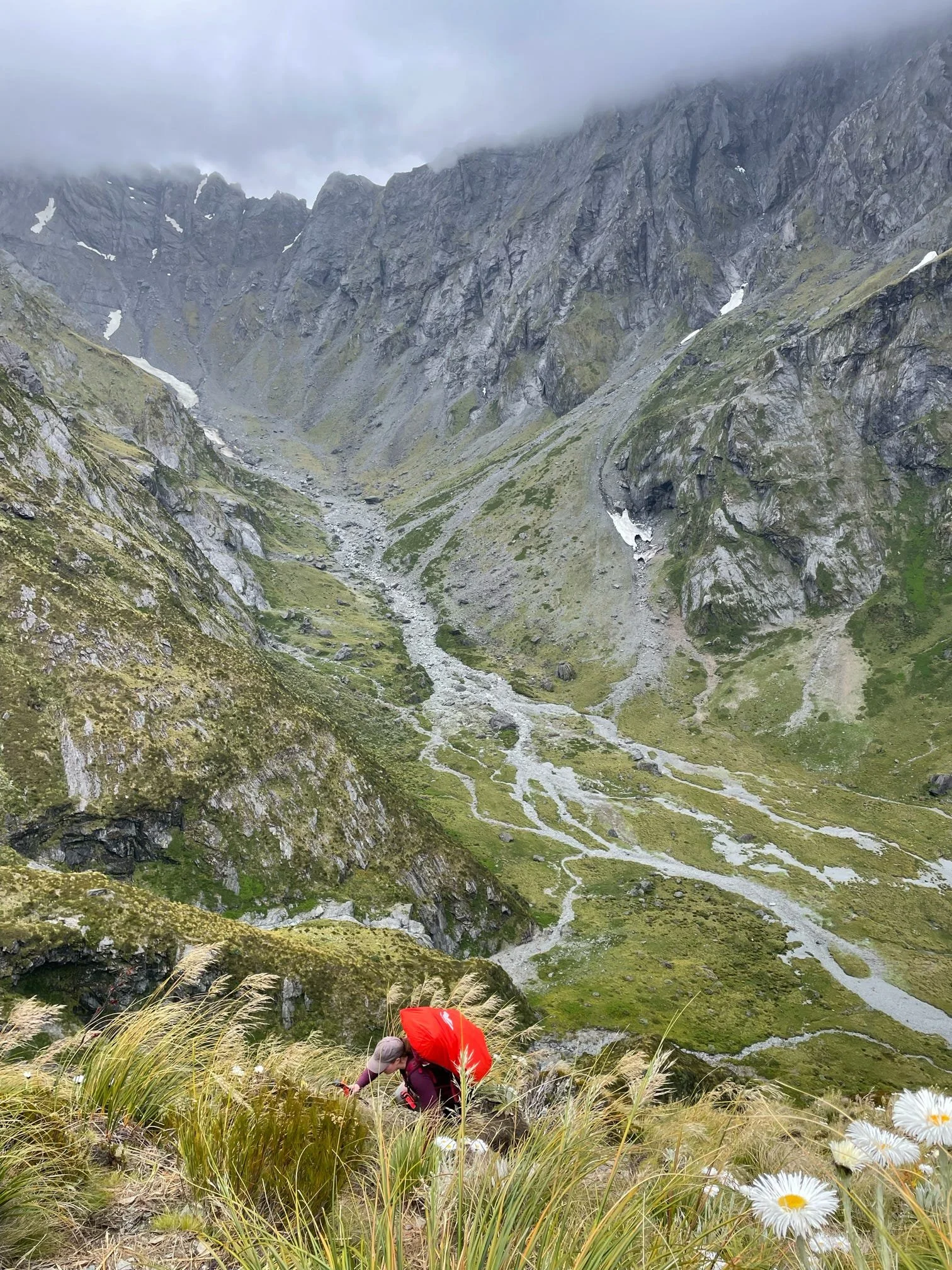
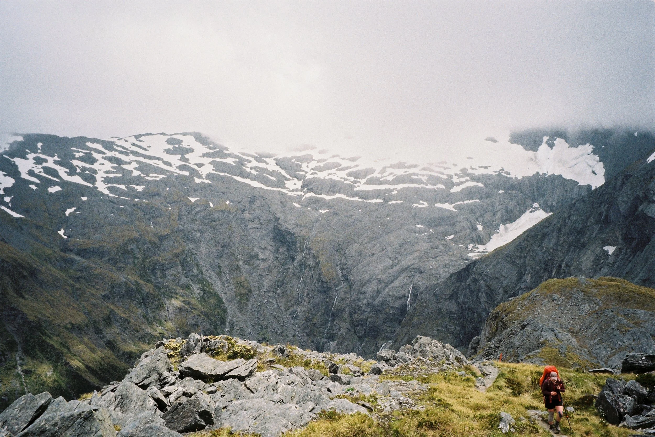
Gillespie Pass. A walk that I genuinely didn't know if I'd be physically capable of completing. A wild 3am night shift idea between my colleague and I, conjured up after one too many shots of coffee and a healthy dose of optimism. Setting out from Wilkin Jets at 9am sharp three weeks later, we made our way up the Makarora River to the mouth of the Young River. Seven hours later we arrived at Young Hut with our newfound Australian friends we'd made on trail. Sleeping bags were set up, gas cookers were on and backcountry meals were devoured. We sat staring at the almost vertical elevation profile of the pass, not making our nerves any less about the day that was to come.
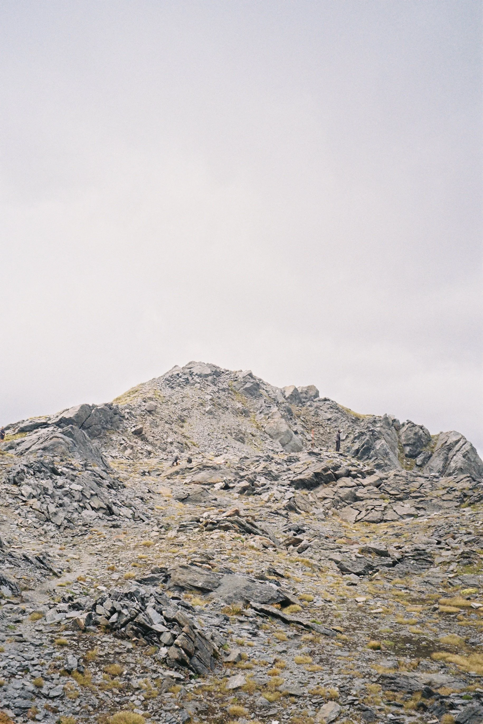
After a sleepless night (whoever has a good nights sleep in a hut, I'm jealous of you) we set off towards the pass bright and early. Standing at the bottom an hour later we looked up at what we had to climb. Very few words were exchanged on the way up. Two hours later, we stood at the top with a view of the very fittingly named Mount Awful. We sat for 20 minutes taking in the view and chatting with the three other groups who we'd shared the hut with the previous night; before beginning to slowly make our way down the pass to Siberia Valley. Who knew I could hate tramping downhill so much. The path to the valley floor felt never ending and for most of the next 4 hours the only thing Sophie and I said to each other was "this sucks, why have we done this" and "I hate this". We finally made it to Siberia Valley just as we were wanting to give up and walked the final 45 minutes to Siberia Hut.
As the sun rose over Mt Awful the next morning we ate our porridge, shoved our sleeping bags into crinkly yellow pack liners and said our goodbyes to our new friends and made our way out of Siberia Valley to the Wilkin River for our jet boat pickup. Sitting on the edge of the river two hours later after a freezing cold dip we recapped every moment over the past 3 days. I've never felt more proud to accomplish a tramp. While it may not be difficult for some people, this one felt more mentally testing than any other I've ever done.
Three days of no sleep. Three days of sore knees. Three days of porridge, salami and backcountry meals. Three days of laughs. Three days of new friends. Three days of fresh air. Three days of incredible views. And that's what it's all about really isn't it. Suddenly you forget the hard bits and all of a sudden it's the best walk you've ever done.
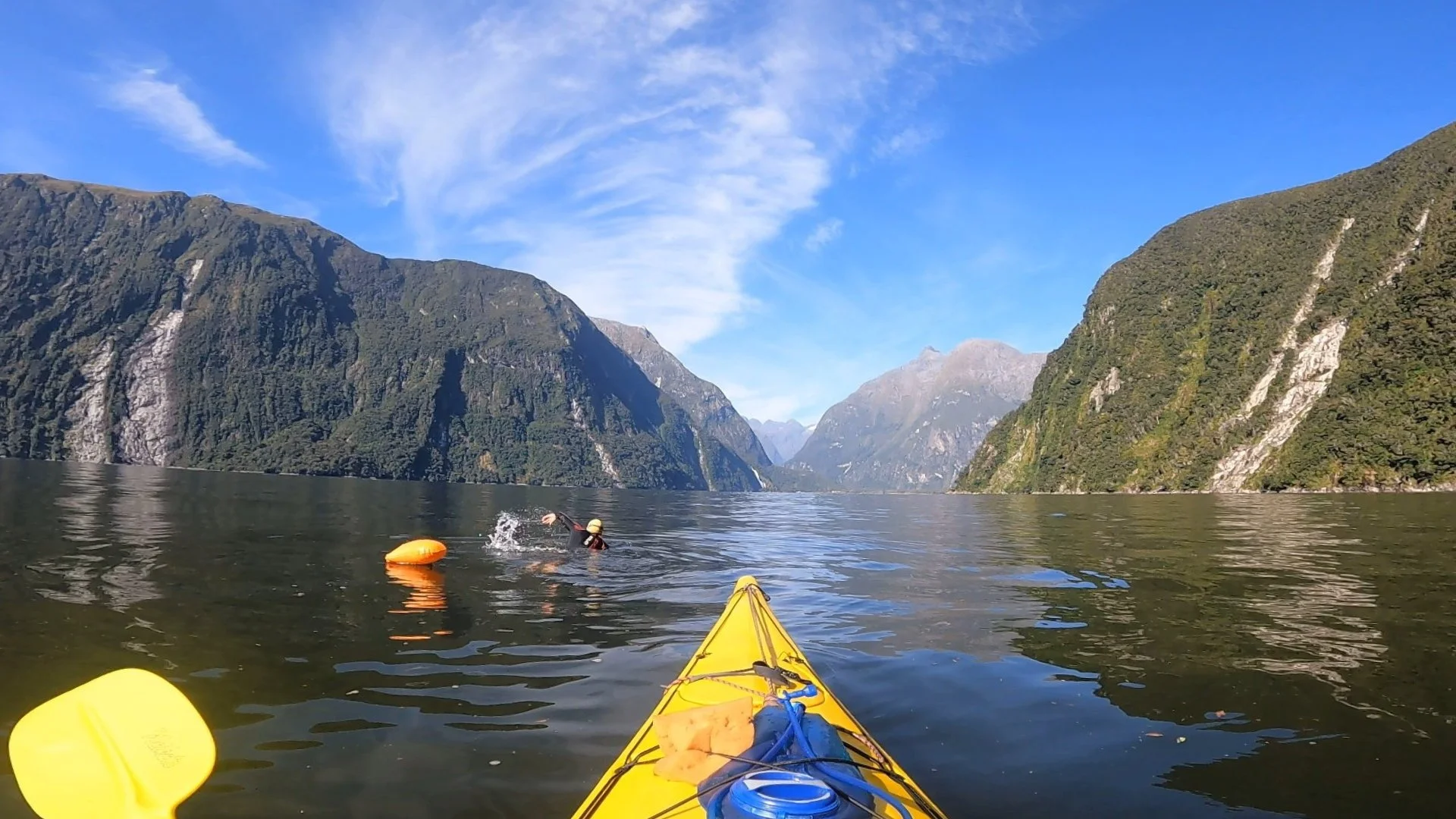
Immersed: Swimming the Length of Milford Sound
Author: Rob Hutchings
Some places in the world breathe with an ancient rhythm; places that feel sentient in their stillness. Aotearoa’s Milford Sound is one of them.
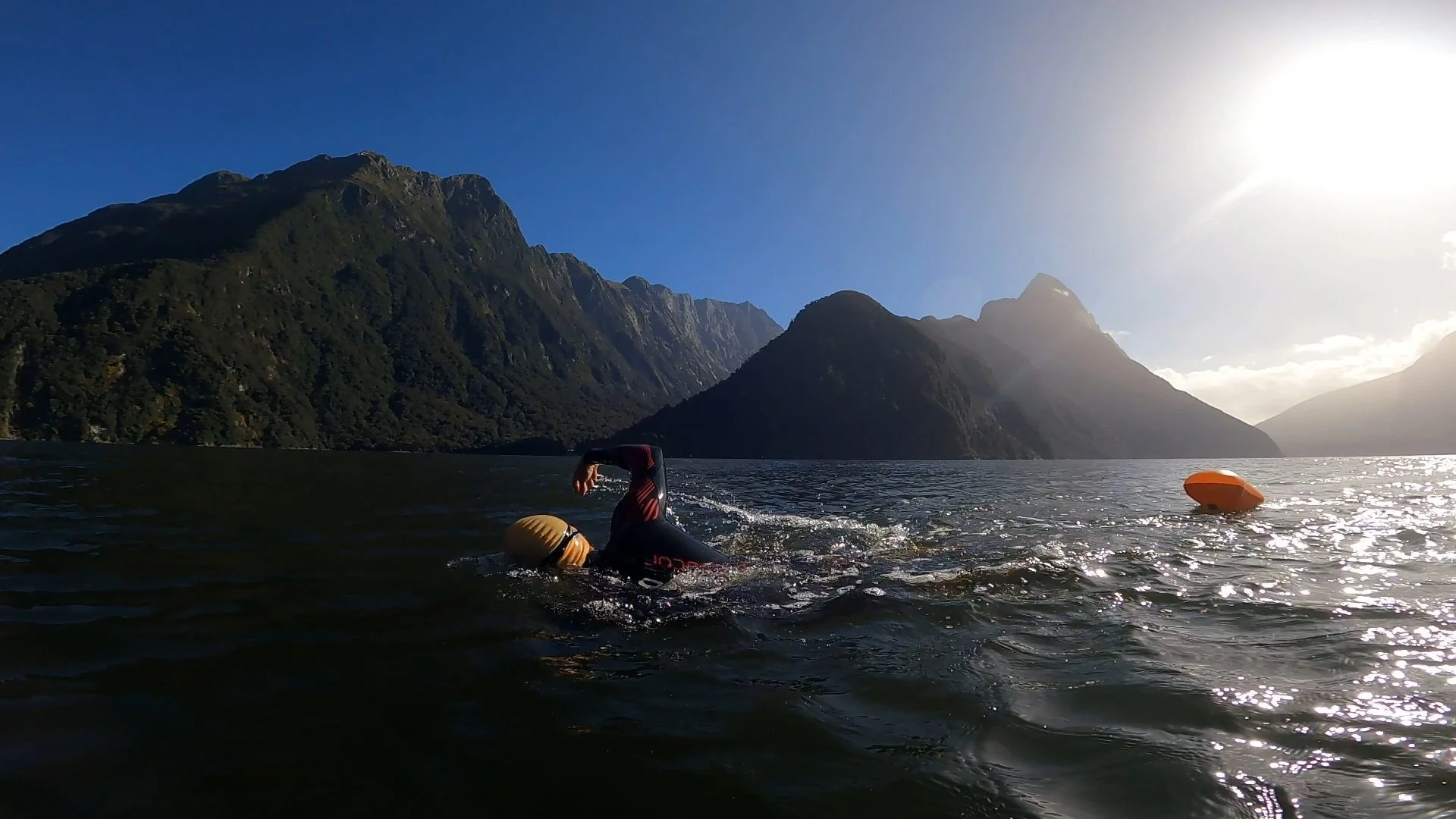
As the water taxi carried me out into the fiord for my open water marathon swim, I watched the granite walls rise abruptly from the water, their forested slopes illuminated in the morning sun. Waterfalls fell like silver threads and the air was so clear it felt almost weightless. The Sound was quiet—strikingly quiet. I was swimming at a rare moment—just before New Zealand’s borders reopened after the pandemic—when visitors were few and water traffic had slowed to a gentle murmur. The fiord felt vast, unhurried, and profoundly peaceful.
Although open water swimming may be considered jumping off a perfectly good boat for no practical reason, when I jumped into the water from my support boat, the busyness and hustle of daily life drifted away. Everything above the surface softened into the distance.
With the first strokes, the world became the cold embrace of the fiord, the echo of my movement, and the towering cliffs standing like sentinels around me. My swim was not about competition. It was about experiencing Milford Sound at water level—its scale, its silence, its presence. And it was about undertaking something no one had completed before: a full-length swim through the fiord, from mouth to head.
What makes swimming Milford Sound extraordinary is that beneath the surface is its unique two-layered water stratification. Although my swim took place on a bright, sunny day, the Sound is often inundated by rainfall that drenches its cliffs. That freshwater runs through forests rich in tannins, staining it a dark amber, which settles atop the heavier, clearer saltwater below. Swimming through this layered environment is unlike anything an open water swimmer typically encounters. I could feel the subtle transitions—the upper freshwater, cooler and slightly dimmed, and below it the familiar buoyancy of saltwater. It was as though I were travelling through two different aquatic worlds.
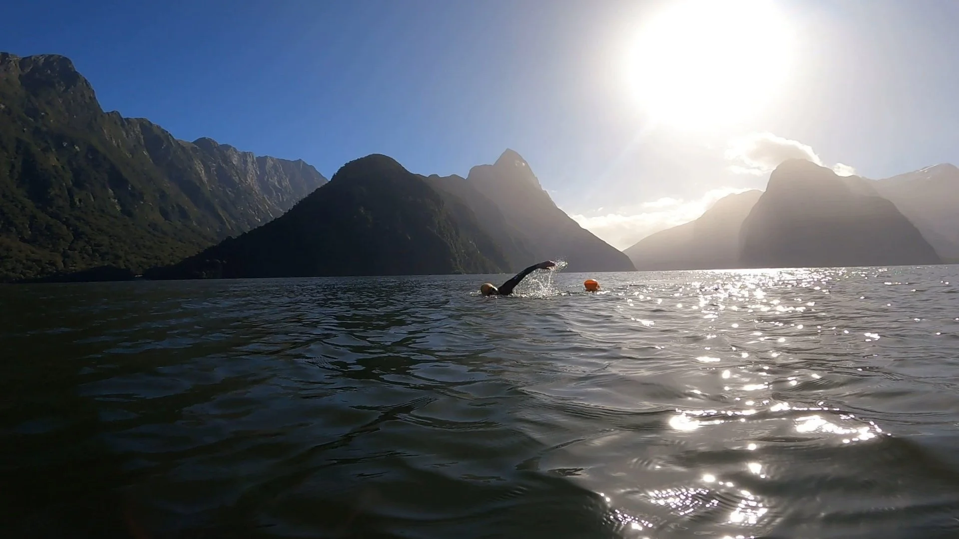
Stroke by stroke, the fiord revealed itself. The cliffs, rising hundreds of metres above me, warped all sense of scale. The air was still. The water was calm. Sunlight rippled across the surface, casting shifting patterns of gold and green. The absence of boat wakes—so unusual for Milford—made the water feel almost sacred, as though the fiord had opened itself just for this quiet passage.
And then came one of the most unforgettable moments of the entire journey. Three dolphins appeared beside me, gliding through the water with effortless grace. At first, I sensed movement beneath me—soft, swift, curious. Then they surfaced, sleek bodies breaking through the water in perfect synchronicity. For several minutes, they swam with me, weaving in and out of my path, circling with playful ease. Their presence was silent but electric, a living reminder that I was not alone in this wild place. They felt like guides—gentle, inquisitive companions who acknowledged my presence in their domain.
As the dolphins moved on and the water returned to stillness, I sank deeper into a meditative rhythm. Three strokes, inhale. Three strokes, exhale. My body found its cadence, and my mind followed. Thoughts thinned. Everything became simple and elemental: the cool water, the long glide, the sound of my breath echoing inside my goggles. The fiord’s silence wrapped around me like a living thing. It was a form of adventure not driven by adrenaline but by presence—the kind that invites you to listen, to feel, to become part of the landscape rather than a visitor passing through.
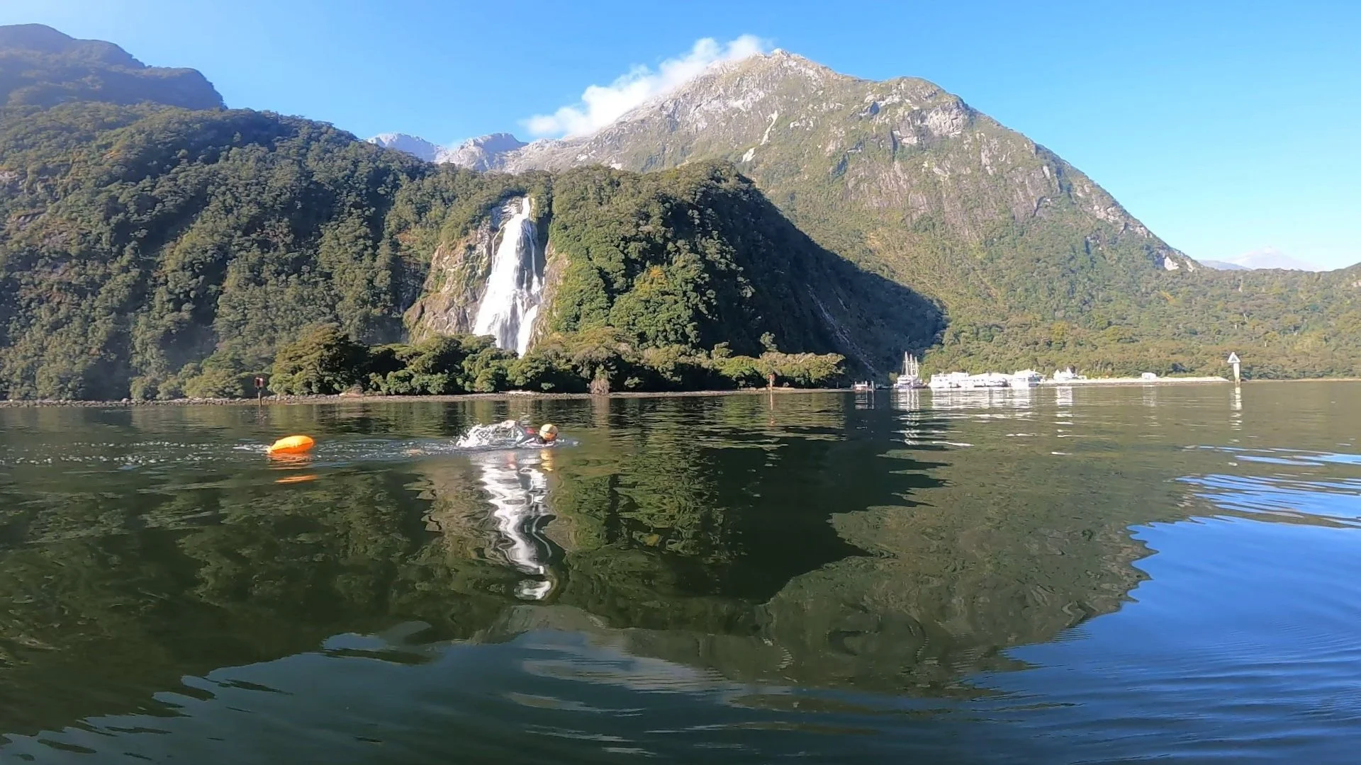
Farther along the fiord, I rolled onto my back for a moment to take it all in. Above me rose Mitre Peak, sharp and iconic against the flawless blue sky. The sun traced its ridges with warm light. Drifting there, buoyed by the saltwater below the tannin-stained layer, I felt tiny, but connected to everything around me. Milford Sound does that. It humbles you and expands you in the same breath.
As I approached the wider stretch near the head of the fiord, a light breeze touched the water, adding a gentle texture to the surface. I lifted my head to see my support team, and a wave of emotion moved through me. I had done it: the first full-length swim of Milford Sound. But instead of triumph, what settled in me most deeply was gratitude. I had moved through this place at its pace, in its silence, experiencing a rare version of the fiord—quiet, unhurried, and almost otherworldly.
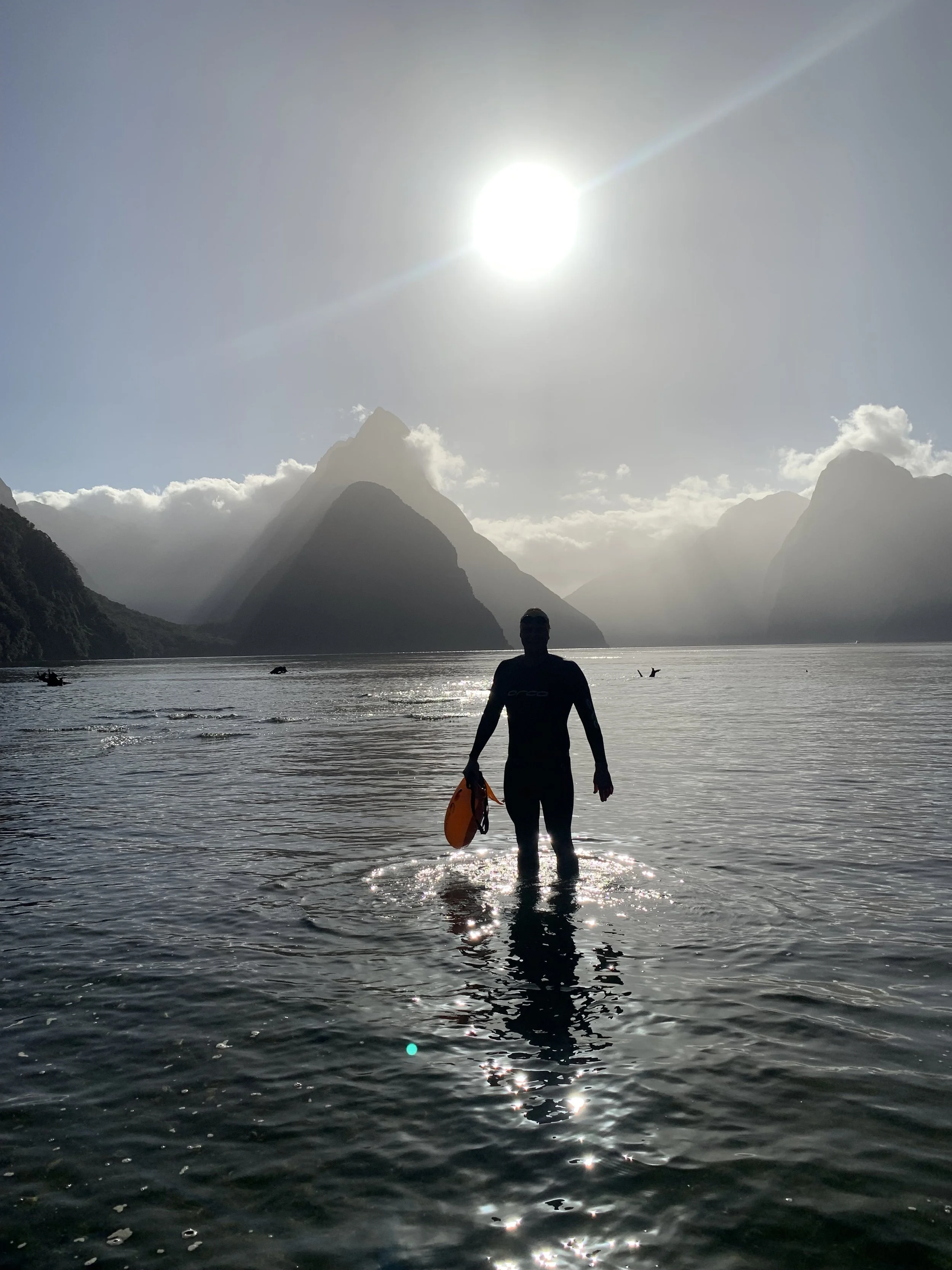
The sixteen kilometre swim reaffirmed my belief that a challenging adventure can be serene and meditative. It can slow you down instead of speeding you up. If my swim inspires anything, I hope it encourages others to step outside, to explore, to seek moments where the landscape invites you in.
You don’t need to swim a fiord to feel the magic. Aotearoa’s outdoors holds countless opportunities from the waterways to the mountains—places where the world feels bigger, where your thoughts feel lighter, and where nature speaks in ways that change you, if you’re willing to listen.
The Wonderful Gillespie Pass Circuit
Author: Sophie Kewish
Wow, where do I begin about this magical tramp?
Truly the best multi day tramp I have ever done. We were so blessed with the weather, met many beautiful people and made some epic memories.
Our first day consisted of a Jet boat to the Young mouth, from there it was a pretty gradual climb up the valley to Young Hut. The final 2 kilometres were bit of a drag, at this point we had done nearly 20kms of walking. Thankfully, after 7 hours we arrived at the hut with the fire roaring, many beds available and a close by swimming hole which we indulged in almost immediately after arriving!
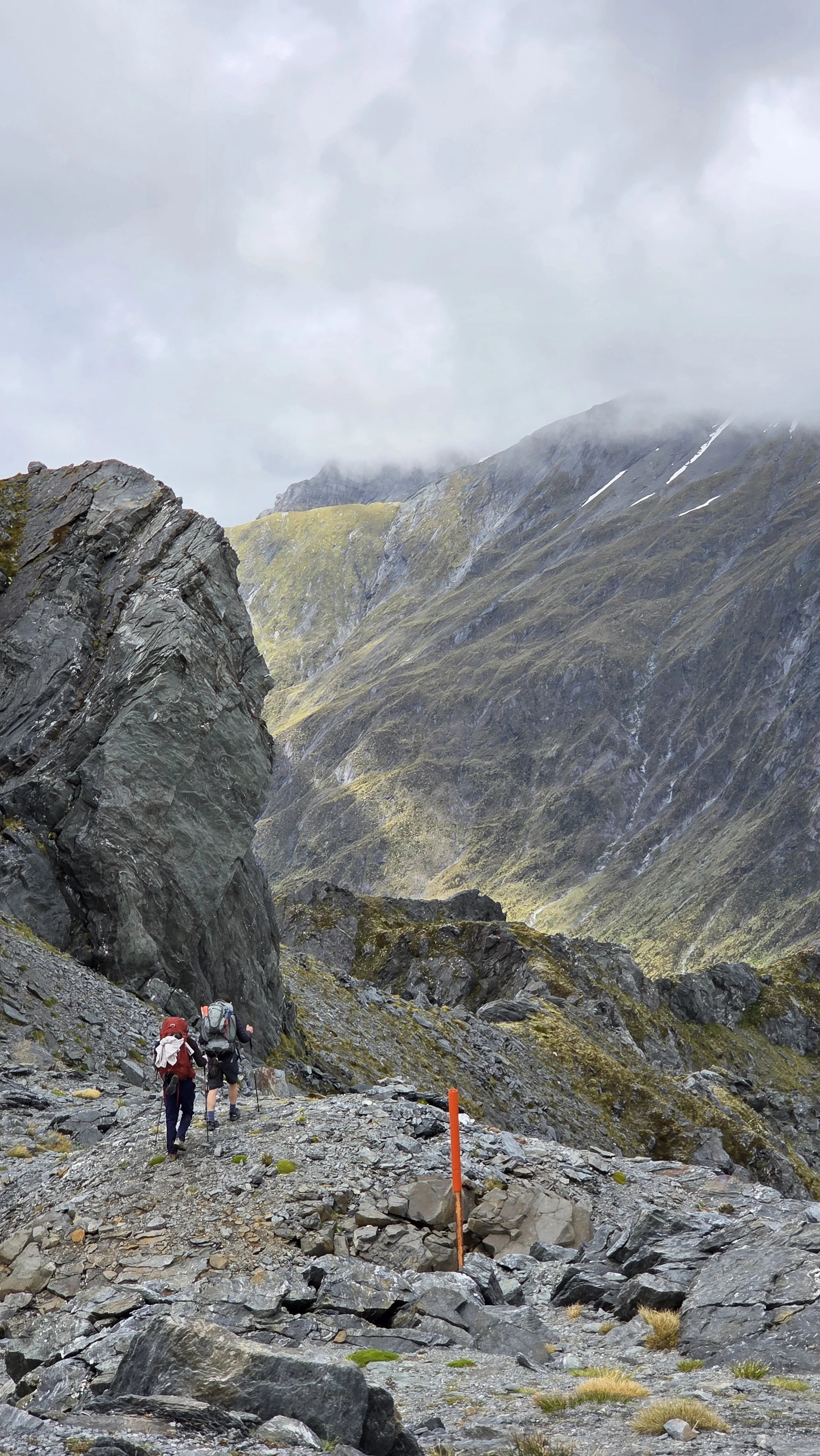
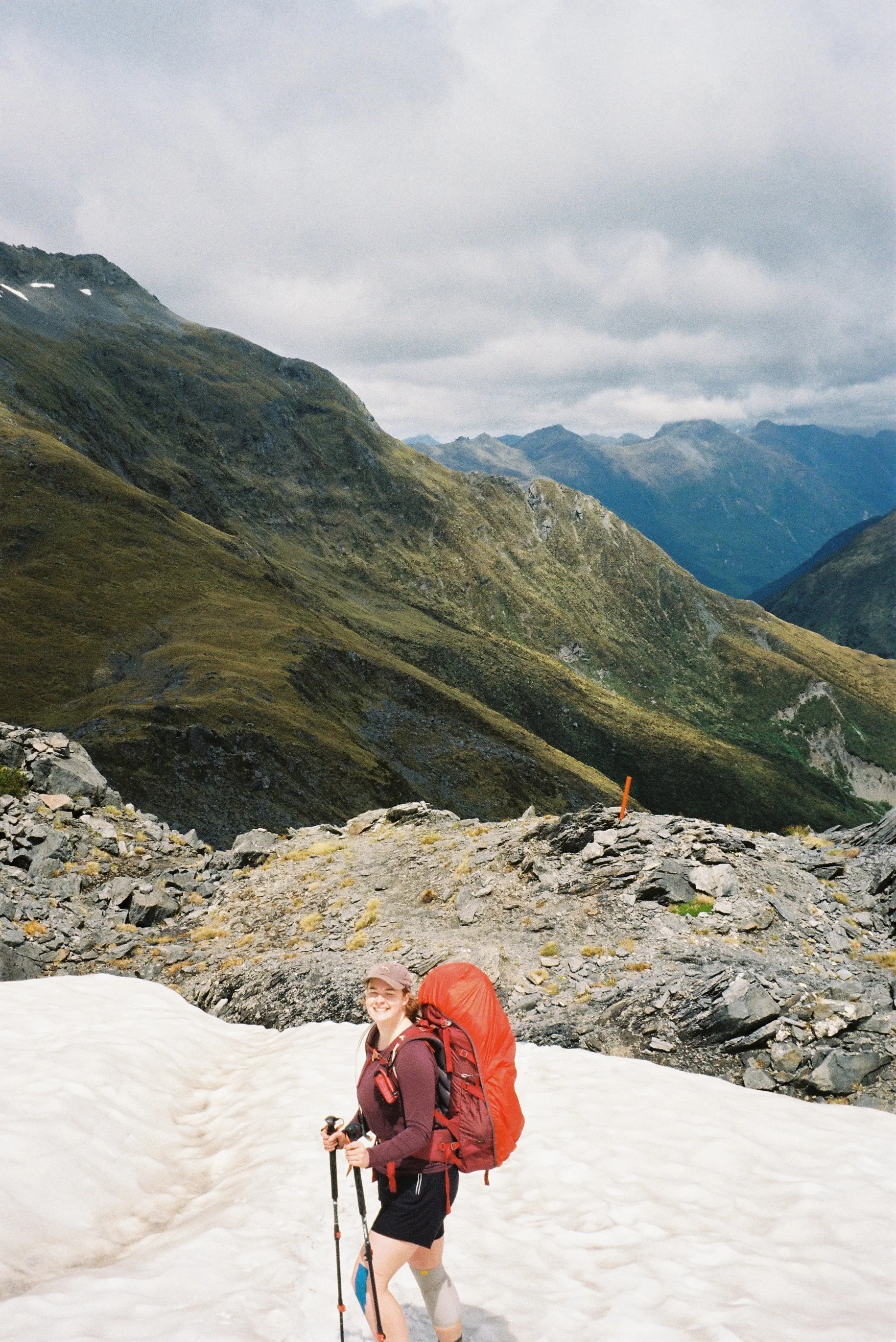
The next day was an early start, just after sunrise we started our hike/climb until we met with the start of the Gillespie pass .. this was an extremely steep climb through snow grass spur. It was an absolute scramble up the pass. After about 4 hours we reached the summit. We were caught with breathtaking views of Mount Dreadful and Mount Awful. After a quick stop at the top (weather started to change rapidly) we stumbled down the mountain and even walked through snow!!
Hours later, we arrived at our camp site for the night with our new Australian friends, made dinner then called it a day.
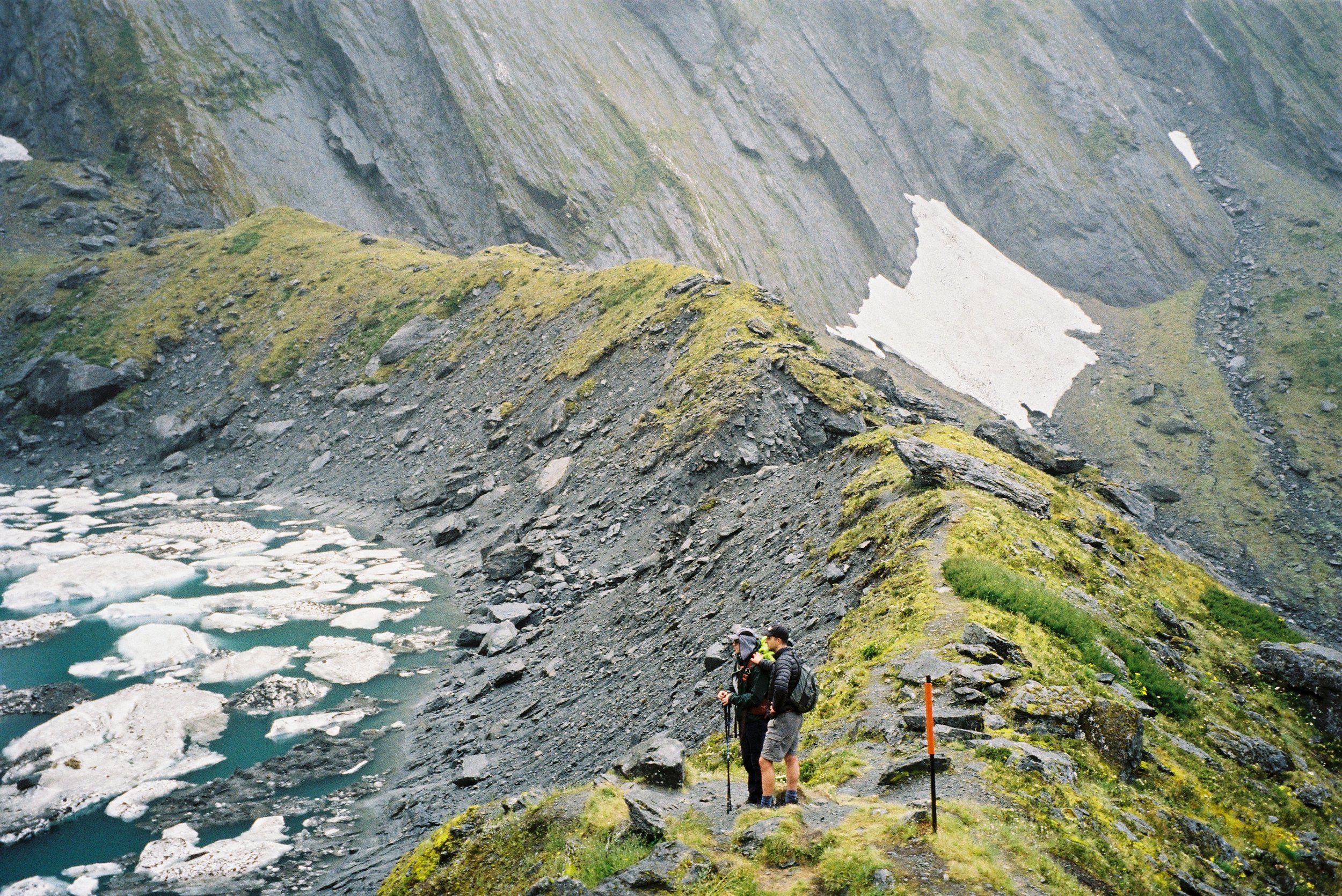
After about 2 hours of sleep in the tent, we woke to the sound of rain and got ready to start our next adventure. Today was tough, we had minimal sleep and the misty rain made it a hard and long climb up to Crucible Lake. It was all worth it when we laid our eyes on the lake. It was the most beautiful lake I had ever seen. Honestly, the misty rain added to the melodramatic lake. We pondered with our thoughts for about an hour while staring at the dazzling scenery. After this unforgetful experience, we grabbed our things and started our trek down the valley.
We packed up our tent and walked 40 minutes to Siberia Hut. We arrived and the sun instantly came out so we knew it was time for a waterfall swim which was close by. Our terribly sore muscles felt at ease and we were able to walk without a limp! We made dinner then sat outside for hours gazing at Mt Dreadful in the distance. What a memorable final night this was.
The final walkout rolls around.. we walked about 3 hours to our jet boat pick up. Thankfully, we arrived an hour early so we managed to get in a lovely river swim and had some snacks while getting eaten alive by the sandlfies!
We hopped on the jet boat and went for a 30 minute ride down the Wilkin river. We were so thankful we booked this as it would’ve made for a very long day, plus a 6 hour drive back to Christchurch!
Remote, Rugged and Beautiful - Hiking to Green Point Hut
Author: Verity Jackson
Something about the Jollie River called to me, maybe it was the idea of following a river deep into the folds of the Mackenzie felt clean, calm — like a fresh start.
Sunshine, clear skies, barely a breath of wind, it felt like a gift. The plan was simple: hike into Green Point Hut and stay two nights, using it as a base to explore further up the valley and locate the derelict Littles Hut. We’d packed tents just in case, when we arrived and spotted only one other car, we took a gamble and left them behind — a decision that, in hindsight, was less than wise.
Through the gate and onto the easement across Braemar Station, the track wound gently through pale gold tussock. After 2.5 kilometres, we crossed into the Gammack Conservation Area — the true beginning of the weekend. The sky stretched cloudless and vast above us, the peaks still dusted with spring snow, the air sharp and clean. The warmth of the sun seeped through my clothes, softening the chill of altitude. There was that unmistakable feeling that comes when summer is stirring, when the land starts to hum again with new energy.
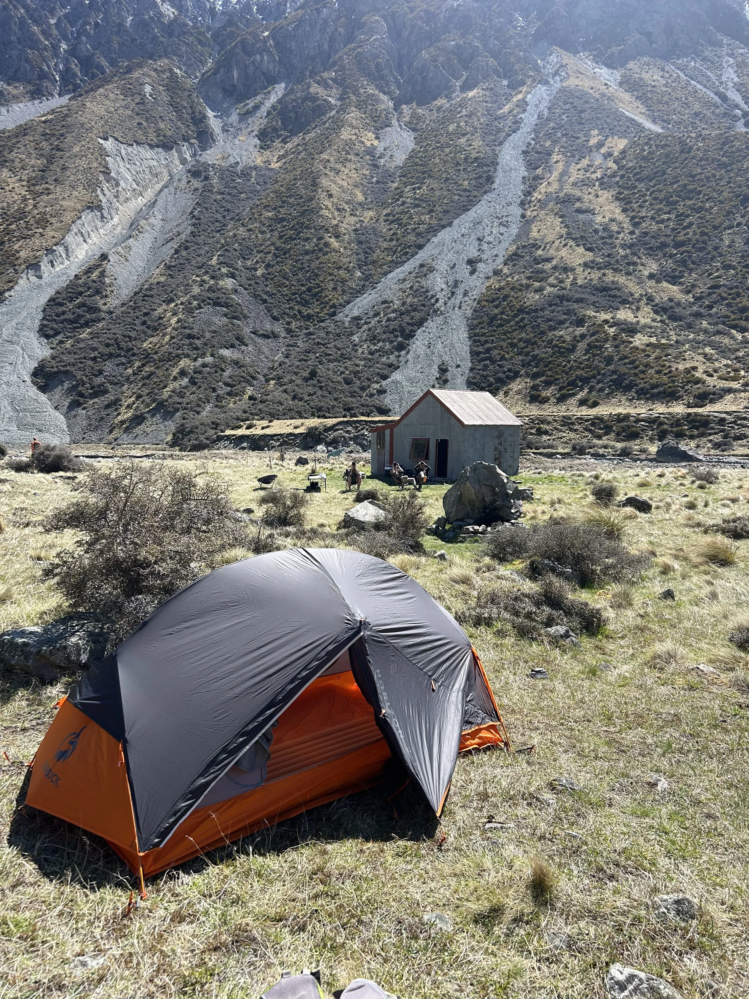
We reached Jollie Hut only 500 metres from the park boundary — an old musterers’ hut from Braemar Station, now managed by DOC. It stood quietly in its clearing, framed by a ring of tall pines, weathered and dignified. A lone mountain bike leaned under a tree, and a few belongings rested neatly on the bench inside.
Leaving Jollie Hut, we descended into the broad terraces of the Jollie River. Downstream, the Ben Ohau Range stretched like a spine beside the turquoise shimmer of Lake Pukaki, while the Burnett Mountains rose to one side and the Gammack Range to the other. Ahead, the Liebig Range loomed white and immense, its peaks still locked in winter. We forded First Creek — icy, swift, knee-deep — then crossed Second Creek, easier and gentler. We stopped for lunch beside a bluff, perching on sun-warmed rocks, surrounded by silence broken only by the distant rush of water.
As we pushed further up the valley, we wove between terraces of tawny tussock and wide stretches of stony riverbed, navigating by instinct as much as by map. The valley began to narrow slightly before opening into a long slip scarred by erosion — and there, faintly visible in the distance, was the hut. Across the slip and closer to the river, we spotted flashes of orange — people. My heart sank. Six bunks, four of us, and now others too.
When we finally reached the terrace, four hunters sat in the sun outside the hut, binoculars in hand, glassing the far slopes. We exchanged greetings and sheepishly admitted we’d left our tents behind, assuming the place would be empty. Instead of turning us away, they offered kindness — and two of their tents. That small gesture, that generosity, reminded me what I’d been missing: the quiet camaraderie of the backcountry — people who want to be here, in the same wild places, for the same reasons.
We set up our borrowed tents in the soft tussock, the late sun draping the valley in gold. As the evening settled, we shared stories, gear tips, and maps. The hunters told us they’d flown over the site of Littles Hut — or what was left of it. “Only a pile of timber now,” one of them said, shaking his head. “No walls, no roof.” Debate followed — whether it still counted as a hut if nothing stood but its bones.
That night, I slept lightly. The sky was a wash of stars, the full moon casting a pale glow across the river flats. Sometime before dawn, the temperature dropped sharply. I woke shivering, the air biting and still. When sunlight finally touched the range tops, a thin frost glazed the tent fly, melting almost instantly in the new warmth.
We left the hut mid-morning, crossed the horse paddock, and followed the edge of a wide shingle fan. Soon, dense matagouri swallowed us. The scrub tangled around our legs, clawing at sleeves and packs. Turning back would have been agony, but pushing forward wasn’t much better. Finally, I spotted a gap — a faint glimmer of light ahead, an opening toward the river. We ducked low, scraping through until we stumbled free onto open stones, laughter breaking through our exhaustion. I was relieved, determined not to return the same way.
Further upstream, two hunters reappeared, crouched beside the river and glassing the opposite face. They waved us over, pointing out the best crossing spot — a small kindness. Beyond them, the valley stretched open and wide. Waterfalls poured from high bluffs, cascading in silver ribbons to the river below. The snow-choked saddle glistened in the distance, unreachable but magnetic.
The map showed Littles Hut near a small scrub terrace. Clambering up through sodden grass, I found a faint track, then a shape in the tussock — rectangular, man-made. A stone foundation lay half-buried in the earth, and nearby, a small iron fireplace still stood upright, stubborn against time. Scattered around was timber — the hut’s remains — stacked neatly like an offering. There it was. The ghost of Littles Hut.
We sat there for a long while, eating lunch in the sun, debating what counted as a “hut.” In the end, we agreed — if the framing and hearth remained, then so too did its story.
After lunch, we wandered further up-valley, hoping to catch a glimpse of the Jollie Saddle, but clouds were beginning to gather over the peaks. Turning back, we avoided the matagouri by staying low, wading along the river’s edge, shoes soaked but spirits high.
Next morning, we packed early, leaving the tents standing to dry — a small repayment for the generosity that had welcomed us. The walk out felt lighter, our pace quicker. As we retraced our steps through the sunlit valley, I reflected on the past two days — the vastness and kindness of strangers.


Flying Solo
Author: Jess Lamb
It was a new year: 2025. New year, new dreams. Time to get at them.
I’d been a trail runner for eight years; an ultrarunner for one. I’d already run two of the great walks out of ten (I don’t count the Whanganui Journey - you can’t run it!), and I wanted to do them all.
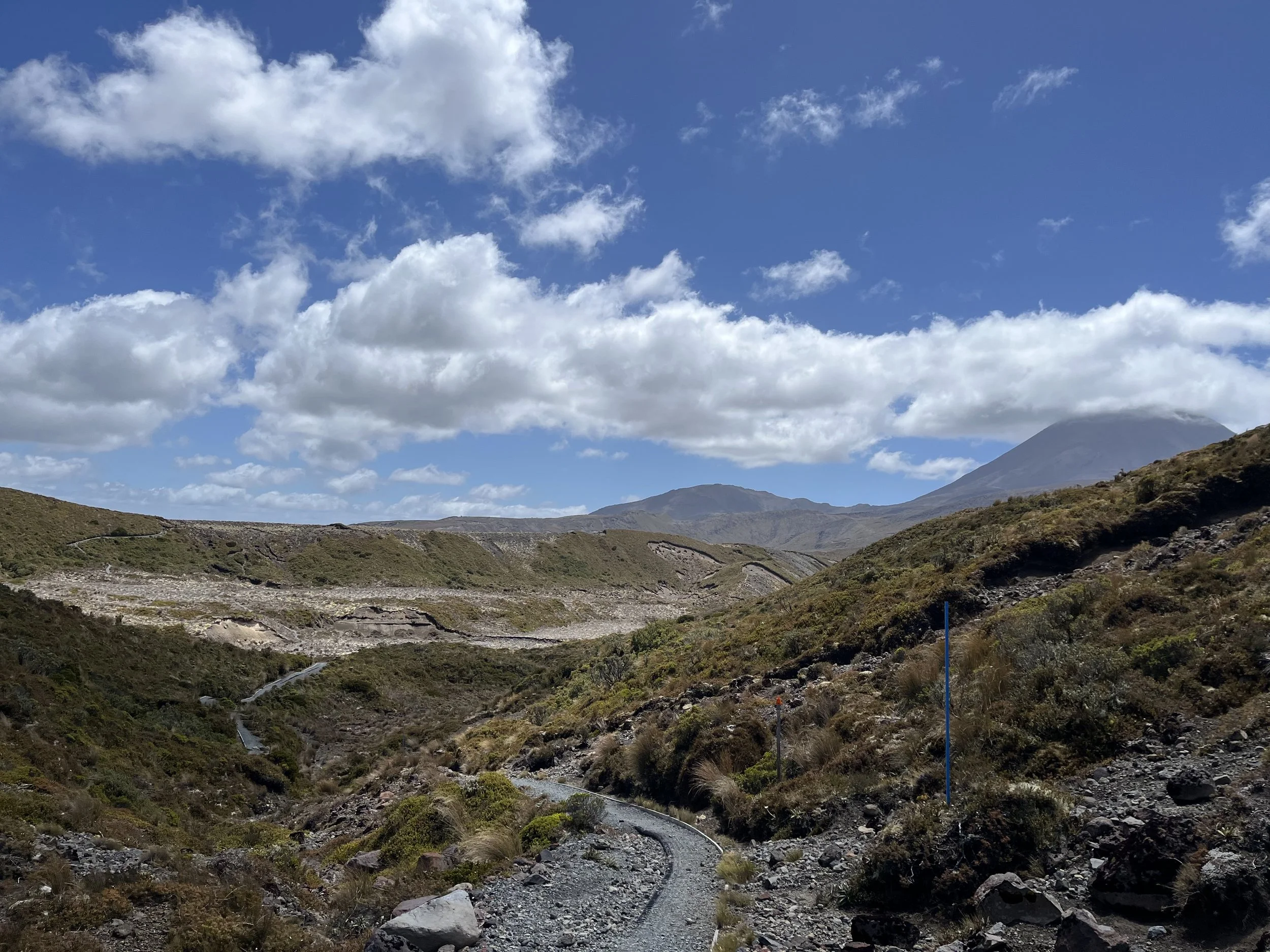
Whilst on summer vacation in Rotorua, it was time to start the year on a high and do my third: the Tongariro Northern Circuit.
I tell my friend, “My New Year’s goal is to run all of the NZ Great Walks during my life. I’m doing Tongariro next week, it should be the easiest to cross off as it’s only like 19km.” She was yet to tell me that it wasn’t the crossing that was certified as the Great Walk, but the Northern Circuit (45km). Turns out I didn’t do my research well, and time and again this would tell.
I posted on my Instagram to see if anyone wanted to run it with me. No one was free. My only option was to run it solo. Being only 21 and new to ultrarunning, this made it a challenge. Sure, I had some backcountry experience, but doing it alone? I guess the only way to get comfortable is to do the uncomfortable.
Next week, I rocked up to Tongariro National Park.
I’d checked the weather; no forecasted rain, check. Snacks, check. Sufficient gear for all weather conditions, check. PLB, check. I was set.
Or so I thought.
One thing I didn’t check was the wind. And it was windy with 85km/hr winds. That’s so windy, in fact, that the alpine crossing had been closed. This wasn’t how it was supposed to go.
I, being a runner who sets their goals and will do them, whatever it takes, meant I didn’t turn around and go home. No, that ain’t the mindset! Instead, I ran part of the circuit, in preparation for coming back, 30km out and back to a hut. And yes, it was definitely windy. Worst headwind in my life.
I got back home, feeling disappointed in not having ticked off another Great Walk. I woke up the next day, severely wind-burnt, and started planning my trip back.
Every day I checked the forecast - this time for rain and wind - with no such luck. Looks like it wasn’t a very summery summer.
Two weeks later, there was an opening in the weather. Time to go! With only one week left in the North Island before I returned back home, it was now or never.
I rocked up again at the Park. It’s raining, and I can’t see any of the mountains. Tomorrow’s the day, I pray to the weather gods, hoping tomorrow’s forecast is better.
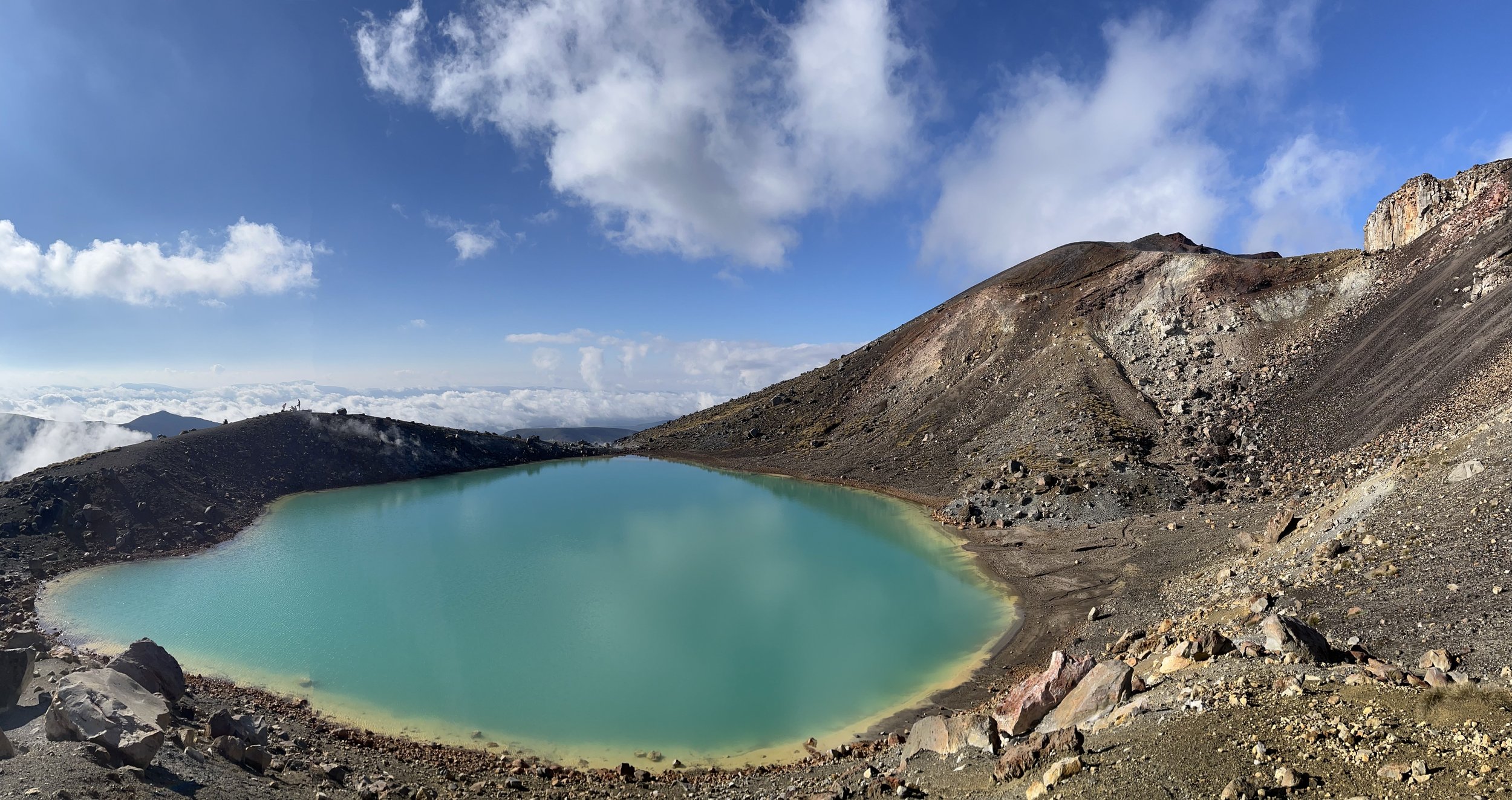
My alarm goes off. I peer out the window. No rain, no wind, just sunshine. Hallaeujuh! It was a stunner of a day, and I was over-the-moon that the weather gods had put on such incredible conditions. I flew up the alpine crossing, and was in awe of the magical emerald lakes on the otherside. I was so starstruck I nearly didn’t see my auntie and uncle on the trail. Pure coincidence they were there.
As I finished the run, smiling ear to ear, with stunning photos on my phone, I caught up with my fam and told them how incredible the trail was.
Tongariro, I’ll be back. Next up, the Heaphy!
Aotea
Author: Hajo Spaethe
Feast the eyes, feed the soul (Whangapoua Estuary, Aotea/Great Barrier Island)
"Happiness...?"
It must be those brief moments when nothing has happened - nor is going to.
Tiny moments like islands in the ocean."
...like mountains pe(a)king through the foggy sea of clouds (Mt. Taranaki)
...like the first or last rays of light to say Hello or say Good night (Westcoast, Shiva Shakti Festival, Auckland)
...like a cuppa of tea (hot chocolate or beer) after a long, hard ride (Harataonga campsite, Aotea offered by the Doc Ranger because I cycled)
...like if you don't know where to stay or sleep for the night and suddenly a car stops, friends jump out by surprise and you go for a hike and stay in a hut (when you meet a friend you met 3 years ago hitchhiking in Raglan, who lives in Auckland on the streets of New Plymouth when all hostels are booked out)
...like a free lightshow for New years night (@tsbfestivaloflights)
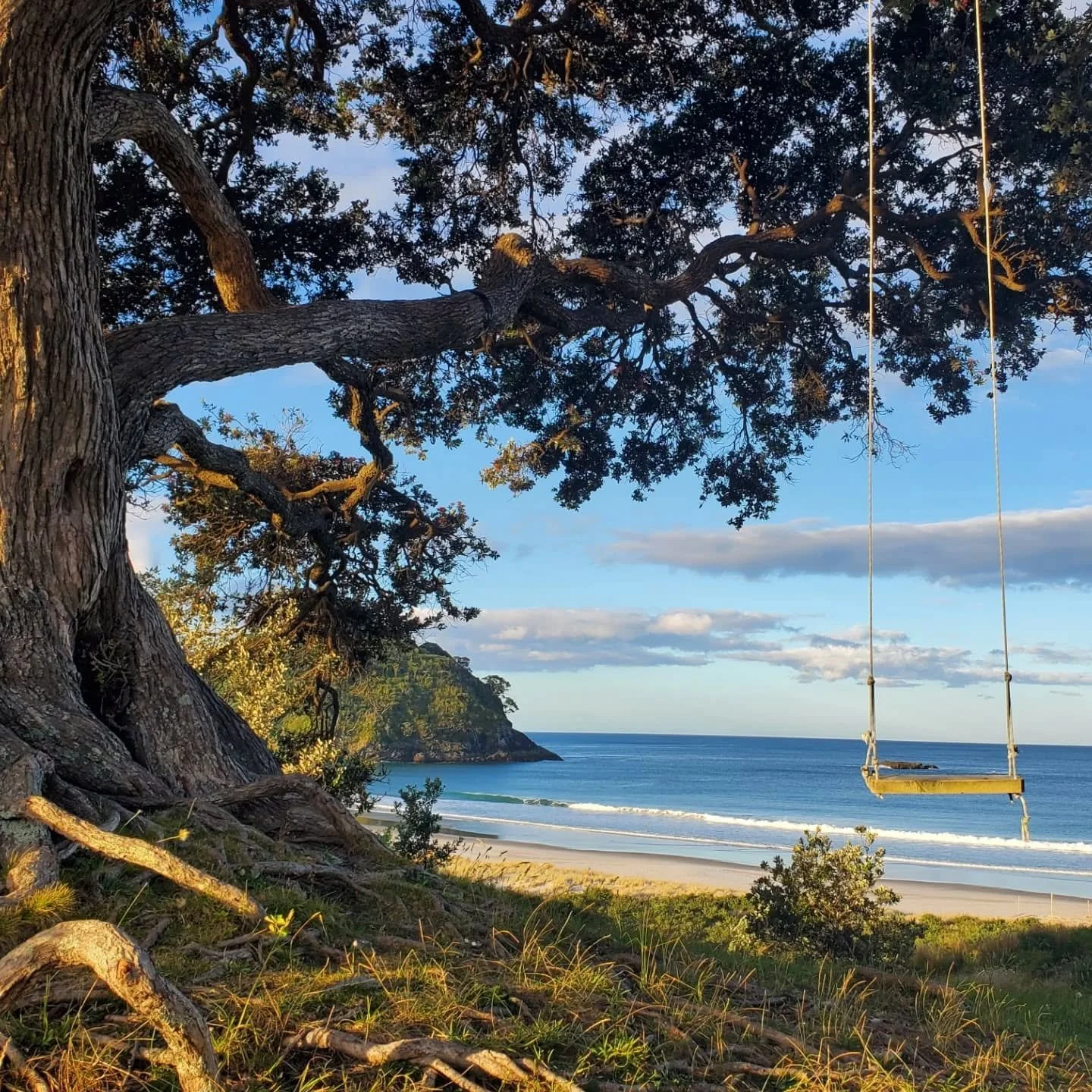
...like a little Christmas letter you find in the mud of a rainy hike (Aotea track) or when you realize how rare it might be to cross path of a caterpillar cocoon getting a ride with a stick insect, a stick insect on a goblin stone in a river, or just an empty swing, so peaceful waving during a sunset in a tree by the sea.
How lucky for me :)